Today the Local Government Commission released its final ward boundaries for Auckland [PDF]. As before, there is significant deviation from equal representation, with wards ranging from 24.8% undersize in the case of Rodney, to 12.8% oversize in the case of Orakei. Here's the full table:
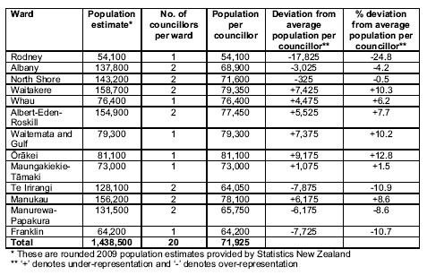
What's interesting is when you compare which wards are under and oversize (boundaries on the Herald here) with the DHB maps from the Atlas of Socioeconomic Deprivation in New Zealand. Notice a pattern? The rich, in Rodney, Te Irirangi and Franklin, seem to be systematically over-represented (meaning their wards are undersized), while the poor, in Waitakere, Whau, Albert-Eden-Roskill, Manukau, and Papakura, are systemtically under-represented. In a ciy designed by ACT. Funny, that.
It is impossible to get wards of exactly equal size, and the Local Electoral Act recognises this by allowing a 10% variation in ward size (the Electoral Act only allows 5%). But while many of the variations fall within the allowance in the Local Electoral Act, their overwhelming direction suggests a systematic bias. The Auckland SuperCity has been gerrymandered in favour of the rich. And that is simply unacceptable.